The Field Photo Library project helps scientists document changes in landscape by sharing crowdsourced and archived field photos from all over the world.
Find more citizen science projects for all five senses on SciStarter.
They say a picture is worth a thousand words, but what value does “any old geo-tagged photo” hold for a scientist? Field Photo Library (official site) is an app that captures images. It is also a partner project of CoCoRaHS, a project that crowdsources weather data to meteorologists to measure rain, hail, and snow. Nolan Doesken, the state climatologist for Colorado at the Colorado Climate Center at Colorado State University says, “It is a fun collaborative effort with many potential applications—drought, inter-annual variability, growing season and phenology, land use change, and, over much longer periods of time, climate change. But it will require establishing a baseline and growing the photo archive from there.”
The project encapsulates the meaning of crowdsourced data collection as well as just how broadly images captured with an iPhone app be used. The University of Oklahoma website which offers a link to the app says, “Every day, researchers, students and citizens use GPS cameras and smartphones to take photos in the field as part of their efforts to document their observations of landscapes, agriculture, forests, natural disasters, and wildlife.”
It would seem intuitive that a landscape photo can tell scientists about land use change over time, and about a sudden catastrophe such as a tornado where there exists a very clear ‘before’ and ‘after,’ but what can a field photo tell a researcher about wildlife for example? In part, the answer to that is ‘ground-truth.’ Mark Shafer, the Director of the Southern Climate Impacts Planning Program and an Associate Professor at the University of Oklahoma agreed that a landscape photograph can assist his biology colleagues when they match research findings to actual landscape photographs, for example as part of a comparative habitat study between wet and dry years.
Having everyone taking pictures at approximately the same time allows us to see a landscape as it relates to the things we measure—how it corresponds to the amount of rain that has fallen, or if it looks like something we might expect according to US Drought Monitor. It seems the real benefit now, is to be able to answer questions such as, “Is the land around you as green as the satellite seems to say?”
Shafer says, “We see a lot of data, but there was no consistent baseline. So that was one of the reasons for starting this project—to create a baseline for drought monitoring, and for seasonal changes.”
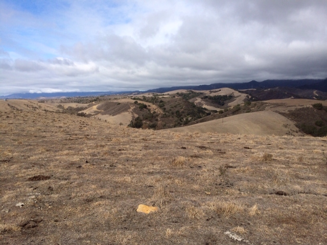
With Santa Barbara currently experiencing a drought, I scooped up my phone, downloaded the app, and headed out to test-drive Field Photo. This PDF explains how to position yourself in your landscape of choice, which is what I did, before capturing a series of images of a nearby valley. And that was that—done and dusted. All I had to do was email the photos in. Instructions for submitting images are provided on this page.
Until now, the app has only been used by a local Oklahoma audience, often as part of an organized Field Photo Weekend, but as Doesken says, “It is now ready to be promoted to a much wider public audience.” Shafer says it would be remarkable if it went global, but for now they are hosting another Field Photo Weekend that will coincide with Presidents Day on February 15. “It would be wonderful if all 19,000 Community Collaborative Rain, Hail and Snow volunteers took a photo for the database this weekend!”
More about Field Photo Weekend: http://www.southernclimate.org
Submitted images will appear here: http://www.eomf.ou.edu/photos/map/#gallery
Download the app: http://www.eomf.ou.edu/photos/
Email photos to fieldphotos@southernclimate.org
Image: Courtesy of Ian Vorster, looking west across a drought-stricken grassland/open shrubland landscape from a vantage point on the western edge of Santa Barbara, California.
Ian Vorster has a MS in Environmental Communications and most recently served as director of communications at the Woods Hole Research Center in Massachusetts. Prior to that he worked in the health communications field. Ian has served as a designer, writer, photographer, editor and project leader in the field of science, and now works freelance in a blend of these roles.