What lives along New Zealand’s shoreline? Find out, one square metre at a time, with Marine Metre Squared.
Looking for more summertime citizen science projects? Find them here.

Every now and again I come across a citizen science project that inspires me. Don’t get me wrong—most of the people I interview, whether they are counting butterflies, measuring the night sky or plotting the paths of ocean behemoths, are in some way stirring, and I am invariably intrigued (and sometimes enchanted) by what they are doing. But only a select few tap the roots of my early childhood aspirations for nature conservation and environmental research. Mothing was one of them. Firefly Watch, which involved intriguing blinking beetles, was another. Now we have Marine Metre Squared (Mm2). It’s difficult to say what makes it inspiring, but I think it has something to do with the enthusiasm the project owners show, how what they are studying reflects the wonder and diversity of life, and just how far the venture has penetrated public awareness. As I write more and more about citizen science, I think of this as a trifecta. When these three intersect a touch of magic is added—something that draws participants toward a lifelong vocation.
“The project is New Zealand based, we want to know what is happening in the New Zealand intertidal zones. However, we have had international visitors complete surveys on New Zealand beaches. It’s an interesting activity and a great way for tourists to explore the New Zealand seashore,” says Tessa Mills, a manager at the New Zealand Marine Studies Centre. “The Seashore ID Guides that we produce are very helpful for anyone joining the Mm2 project—they are taken home as souvenirs by many international visitors!”

More than 700 people have registered, consisting of a combination of schools (46%), individuals (30%), families (14%), community groups (8%) and tertiary institutions (3%). This is shared equally between the north and south island. “Although not everyone is contributing data we expect that the data submission will grow over time. And the project can be adapted for preschool groups; for example playing eye-spy in a one-meter area. And although they may not be able to identify or count all the species, they may be able to choose one species to look for and count” says Sally Carson, the director of the New Zealand Marine Studies Centre. “Similarly we have had some very knowledgeable individuals say that they have spent almost three hours counting and identifying what is in their square.” To help evaluate the quality of the data collected, the Centre is asking participants to rate the scientific accuracy of the data collected as low, medium or high. That seems to be a unique addition to citizen science—rating the quality of the data you collect is an added element of verification.
The photographic Seashore Guides (Sandy, and Muddy and Rocky) have been incredibly popular with over 140,000 copies being distributed free of charge thanks to Mobil Oil New Zealand Ltd. At first glance, muddy and sandy shores appear barren, but look beneath the surface and you will find a rich diversity of life—as the Maoris say, “Ngā tini o te waitai.” Northern and Southern versions have been compiled to highlight New Zealand’s regional differences. The guides not only feature the plants and animals that live on the shore, but also illustrate the evidence that they leave at the surface; for example, the telltale burrow and volcanic mound of the mantis shrimp. The guide encourages visitors to act as detectives, and find out what lives there without disturbing the habitat.
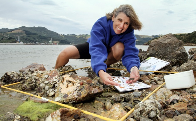
“We often compare our meter squared quadrant to binoculars. It encourages people to focus on one area and look closer. They are always amazed at what they find,” says Carson. In New Zealand, as in most parts of the world, the coastline is accessible to so many people, yet many know very little about their seashore neighbors. Mm2 hopes this project will help facilitate a global shift towards guardianship of the local environment by the communities that understand the ecosystems they live in and interact with. “While this approach has huge potential, the transition must come with the tools and education to make real community guardianship of the environment successful, and Mm2 is an effective first step in the process,” says Carson. The partnerships that are developing between schools, scientists, community groups and families are key to the success of such an approach. Sounds like fertile soil for that trifecta.
Resources:
Mm2 Guide
Photo credits: Tessa Mills (top), Kimberley Collins (middle left), Sharron Bennett (bottom right)
Ian Vorster has a MS in Environmental Communications and most recently served as director of communications at the Woods Hole Research Center in Massachusetts. Prior to that he worked in the health communications field. Ian has served as a designer, writer, photographer, editor and project leader in the field of science, and now works freelance in a blend of these roles. You can see more of Ian’s work at dragonflyec.com.